The Thriplow Landscape Research Group set themselves the task of answering the question “Why is Thriplow in its present shape?”
To answer this question they did a lot of walking and observing, learned surveying techniques, and studied the local geology, ecology, archaeology and history.
In 2004 the Group published a book called “Thriplow Time Trails”. This sold out quickly but there are online sources that describe what the group did and what they found out.
For example they learned how to use an auger, a digital theodolite and a resistivity meter. They found some Roman coins (an example is shown below), studied the crop marks in aerial photographs and tried to make sense of the lumps and bumps in Thriplow – house platforms, the result of digging for clunch, or the result of water movements?
They looked at the written sources from 991 when Ealdorman Bryhtnoth bequeathed his estate in Thriplow to the Abbot of Ely to the present day, and tried to make sense of the fluctuating population figures in the light of climate, disease and changing land use.
An as dated Trajan A.D. 98-117. Reverse is Fortuna standing.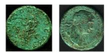
To get a flavour of their work see http://www.tlrg.rheesearch.org.uk/Index.htm
and this BBC Local History article published in 2005 entitled “History of a Landscape: Thriplow”.